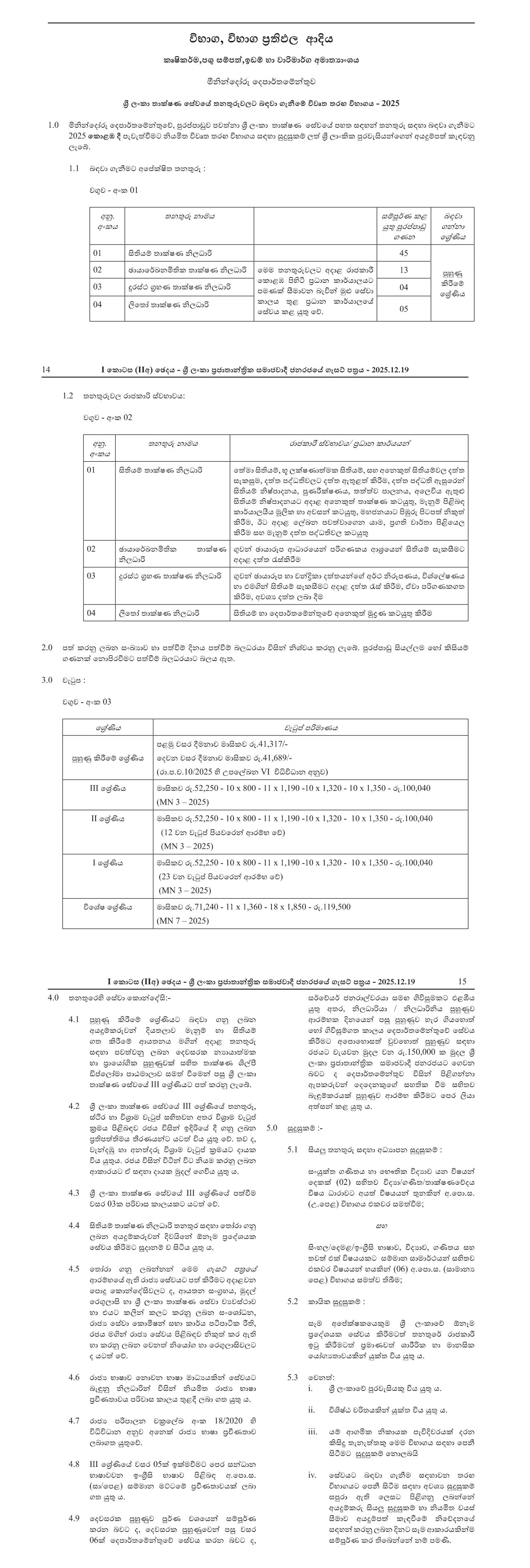
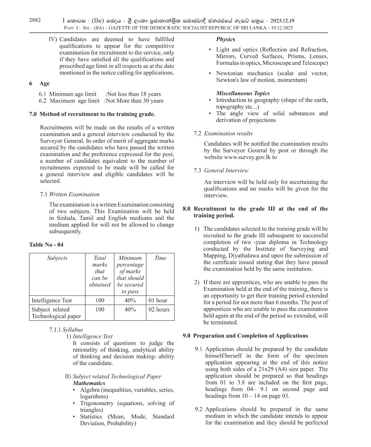
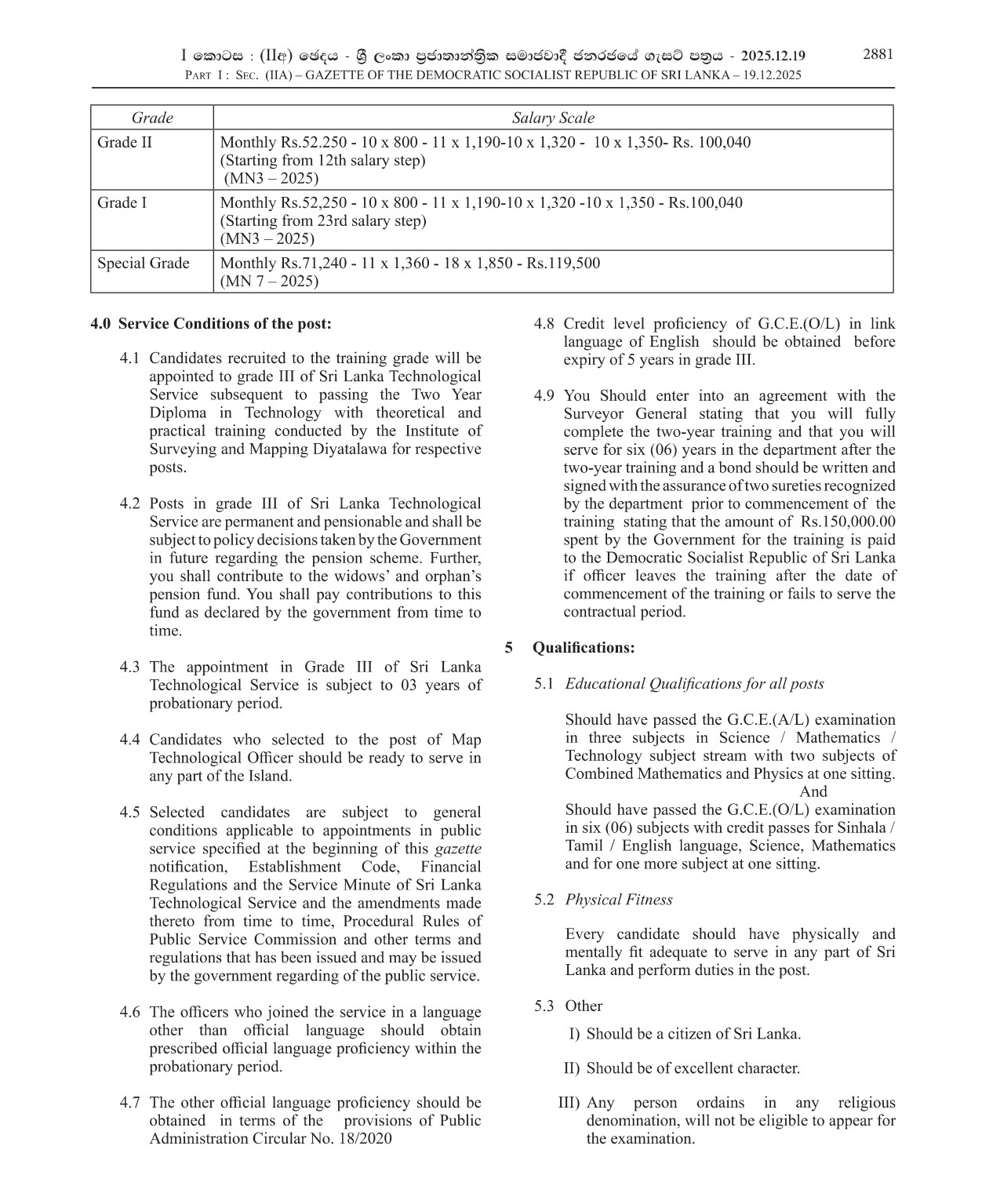
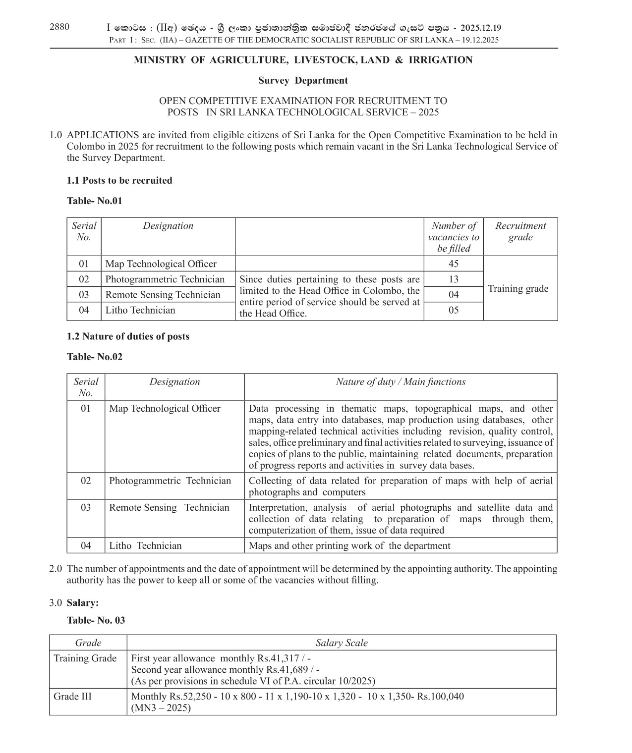
Ministry of Agriculture, Livestock, Land & Irrigation
ñkskafodare fomd¾;fïka;=j
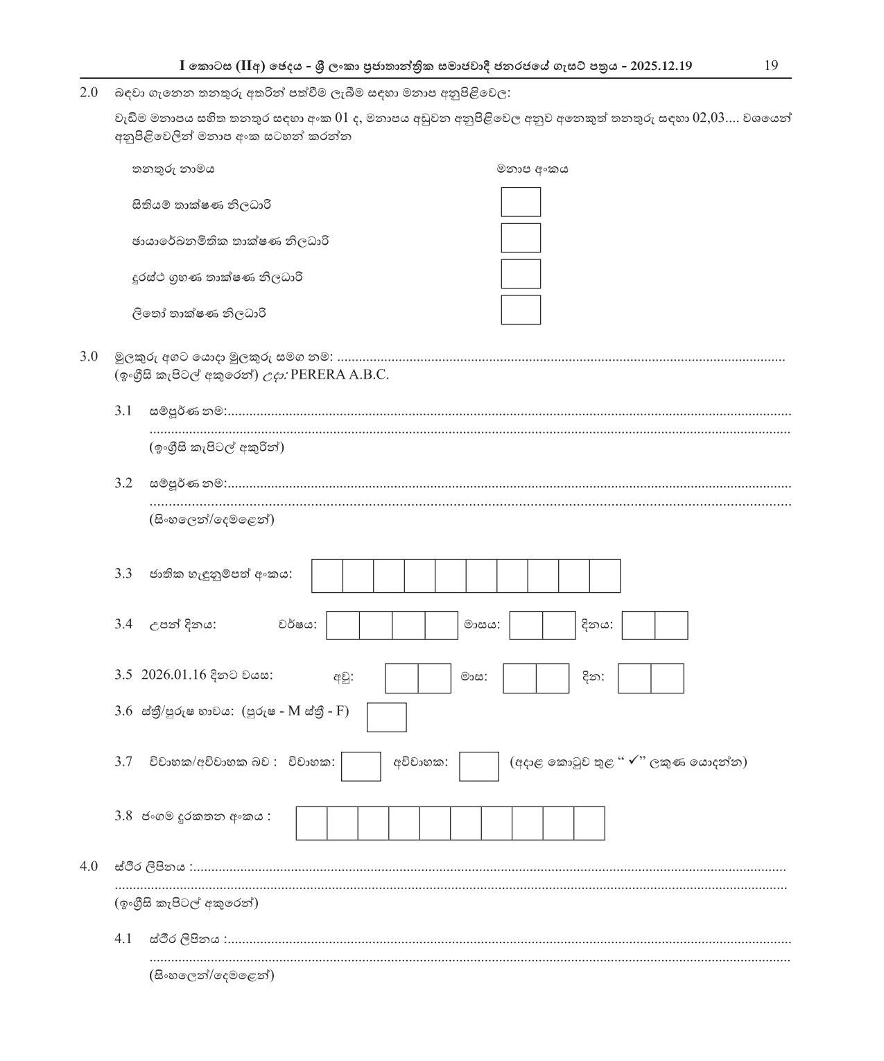
- is;shï ;dlaIK ks,OdÍ
- Pqdhdf¾Lkñ;sl ;dlaIK ks,OdÍ
- ÿria: .%yK ;dlaIK ks,OdÍ
- ,sf;da ;dlaIK ks,OdÍ
- Map Technological Officer
- Photogrammetric Technician
- Remote Sensing Technician
- Litho Technician
Job Description
Join the Ministry of Agriculture, Livestock, Land & Irrigation team as a Map Technological Officer, Photogrammetric Technician, Remote Sensing Technician, or Litho Technician. As a leader in the agriculture industry, our mission is to promote sustainable farming practices and ensure food security for all. In this role, you will be responsible for utilizing advanced mapping technology to analyze and map agricultural land, monitor crop growth, and identify potential risks. You will work closely with our team of experts to collect, process, and analyze data using photogrammetry, remote sensing, and lithography techniques. The ideal candidate will have a strong background in geography, geomatics, or a related field, along with experience in GIS software and data analysis. A passion for agriculture and a desire to make a positive impact on the environment and food production is a must. Join us in our mission to revolutionize the agriculture industry and contribute to the growth and development of our nation. Apply now and be a part of our dynamic team at the Ministry of Agriculture, Livestock, Land & Irrigation.

Similar Jobs
-
University of Ruhuna
reyqKq úYajúoHd,h
Published Date: 2/23/2026Senior Assistant Registrar (Legal & Documentation) , Workshop Engineer , Electronics Engineer , Curator (Landscape) , Statistical Officer , Scientific Assistant , Assistant Network Manager , Programmer/System Analyst , Instructor
fcHIaG iyldr f,aLldêldÍ ^kS;s yd f,aLk& " jevuq¿ bxðfkare " bf,lafg%dksla bxðfkare " WoHdk md,l ^NQ w,xlrK& " ixLHdk ks,OdÍ " úoHd;aul iyldr " iyldr cd,lrK l,ukdlre " jevigyka iñmdol$moaO;s úYaf,aYl " WmfoaYl
-
Gampaha Wickramarachchi University of Indigenous Medicine
.ïmy úC%udrÉÑ foaYsh ffjoH úYajúoHd,h
Published Date: 2/18/2026Management Assistant (Store Keeping , Book Keeper) , Pharmacist , Technical Officer , Security Inspector , Driver , Electrician
l,ukdlrK iyldr ^.nvd Ndrlre " fmd;a ;nkakd& " T!IOfõ§ " ;dlaIK ks,OdÍ " wdrlaIl mÍlaIl " ßhÿre " úÿ,s ld¾ñl
-
Sri Lanka Institute of Textile & Apparel
Y%S ,xld fmaIl¾u yd weÛ¨ï wdh;kh
Published Date: 2/23/2026Board Secretary
wOHlaI uKav, f,alï
-
University of Moratuwa
Published Date: 2/12/2026Senior Lecturer , Lecturer
-
University of Moratuwa
fudrgqj úYajúoHd,h
Published Date: 2/20/2026Pharmacist , Public Health Inspector , Driver , Mason , Plumber , Welder , Tractor Operator
T!IOfõ§ " uyck fi!LH mÍlaIl " ßhÿre " fmof¾re " c,k, ld¾ñl " mEiaiqïlre " g%elag¾ C%shdlre
-
University of Ruhuna
reyqKq úYajúoHd,h
Published Date: 2/23/2026Senior Assistant Registrar , Works Supervisor , Pharmacist , Public Health Inspector , Plumber , Attendant
fcHIaG iyldr f,aLldêldÍ " jev mßmd,l " T!IOfõ§ " uyck fi!LH mÍlaIl " c, k, ld¾ñl " Wmia:dhl